Politics & Government
Republican National Convention Delayed By Tropical Storm 'Isaac'
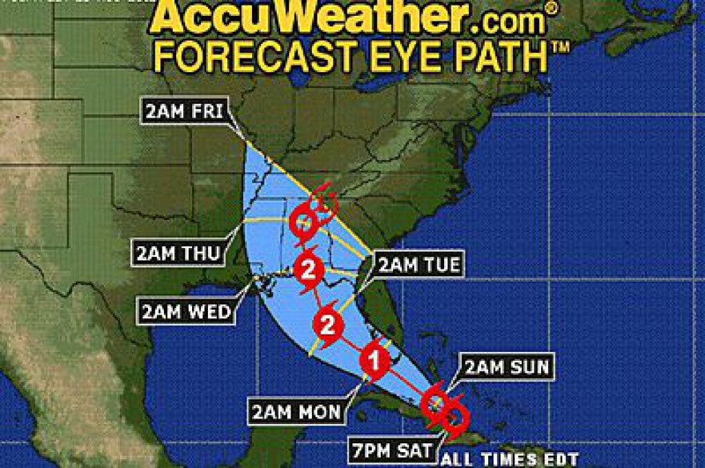
Isaac is forecast to reach the eastern Gulf of Mexico on Monday, coinciding with the scheduled start of the Republican National Convention.
This information is provided by AccuWeather.com
AccuWeather.com reports as delegates and the media gather for the 2012 Republican National Convention in Tampa, Fla., Aug. 27-30, a passing visitor, "Isaac," will have a little say.
Isaac is forecast to reach the eastern Gulf of Mexico on Monday, coinciding with the scheduled start of the Republican National Convention, says Alex Sosnowski, expert senior meteorologist for AccuWeather.com
The Republican National Convention will convene on Monday morning and immediately be postponed until Tuesday afternoon. The decision was made to protect people attending the event as Isaac impacts parts of Florida early this week.
This track will be a glancing blow to the Tampa area. Heavy rain, thunderstorms, gusty winds, urban flooding and above-normal tides will affect the Florida west coast as well as a significant portion of the peninsula as Isaac approaches and passes by to the west over the Gulf. Such a track will also bring the potential for a few tornadoes.
Tropical Storm Isaac, which moved swiftly along as a minimal tropical storm much of this week, will reach the Florida Straits later this weekend and beginning strengthening into a hurricane.
AccuWeather.com Hurricane Center meteorologists anticipate the storm reaching the Gulf of Mexico by Monday. Upon entering the Gulf, a gradual turn more to the north is anticipated.
People from the Florida Panhandle to coastal Mississippi should be preparing for a possible direct hit from a Category 2 (or stronger) hurricane at this time.
A strengthening hurricane over the eastern Gulf of Mexico will bring building seas and rip currents to a large part of Florida's western coastline. The "backwash flow" or west to southwest winds from a strengthening system moving to the north will produce above-normal tides in Tampa.
At present forward speed (approximately 15 mph), the greatest impact in the Tampa area is likely to occur Monday into Tuesday with conditions potentially deteriorating during Sunday night, depending on the nature of spiral bands preceding the system.
Rainfall totals in excess of 4 inches are expected to inundate Tampa Sunday night into Tuesday. The steadiest rain will pour down on Monday with spottier, yet still soaking showers and thunderstorms to follow Monday night into Tuesday.
Tropical storm-force wind gusts (likely around 50 mph) will buffet Tampa Monday into Monday night. Winds of this strength could down tree branches and toss about loose lawn items.
Isolated tornadoes will become a concern Monday night into Tuesday as the center of Isaac passes by to the north, on a path to strike the northern Gulf Coast as a Category 2 (or stronger) hurricane around Tuesday night.
Interestingly, rain from Isaac after moving inland could soak Charlotte, N.C., site of the 2012 Democratic National Convention. While the rain will have left the Queen City well prior to the start of the convention slated for the week of Sept. 3, there is a risk of flooding in the area for travelers and last-minute preparations.